A completely different course than planned
It's the middle of the COVID-19 pandemic, everything has already been shut down for a couple of weeks, and outside selling is nearly impossible because the people who still have money are clinging on to it. I have a big case of cabin fever, so going on a backpacking trip seems like a perfect way to socially distance, let off some steam, and audit the fourth amendment's effectiveness.
The out-and-back course I originally planned started at the Duke Power Tuxedo Hydro Station parking lot and stayed relatively near the plant. Everything was mapped, planned, and ready until the guard at the gate (I didn't even know there would be a gate) told me that nobody was allowed to pass except power plant employees due to COVID-19 and because there were already going to be more workers at the site than normal due to scheduled maintenance.
Fortunately, less than a mile up the road there was a trailhead for the Foothills Trail, which was familiar because my last backpacking trip was on a different section of the same trail. Since the previous section I backpacked was well maintained and well marked, I started hiking North from here with my GPS but without a trail map.

My starting point on Highway 281 in North Carolina less than a mile past the SC/NC border


A sign 0.8 miles from my starting point. If I would have gone the other way on the trail I would have seen sections of the Foothills Trail from my previous hike.


All areas I've seen on the Foothills Trail are well maintained with ample bridges. It is amazing how so many of these huge structures in the middle of nowhere are accessed, built, and maintained.


Well-maintained trails are a welcome sight.

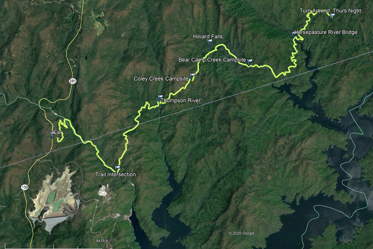
This photo and the next two are shot in the same location 3.1 trail miles from the starting point. This location is notable because it is where the Foothills Trail and my originally planned trail intersect. I decided to continue on the Foothills Trail.


Thompson River, where I stopped for lunch. I didn't jump in the water and sun bathe on my first day, but I wanted to make a point of it on my return hike. This is 5.8 trail miles from the car.

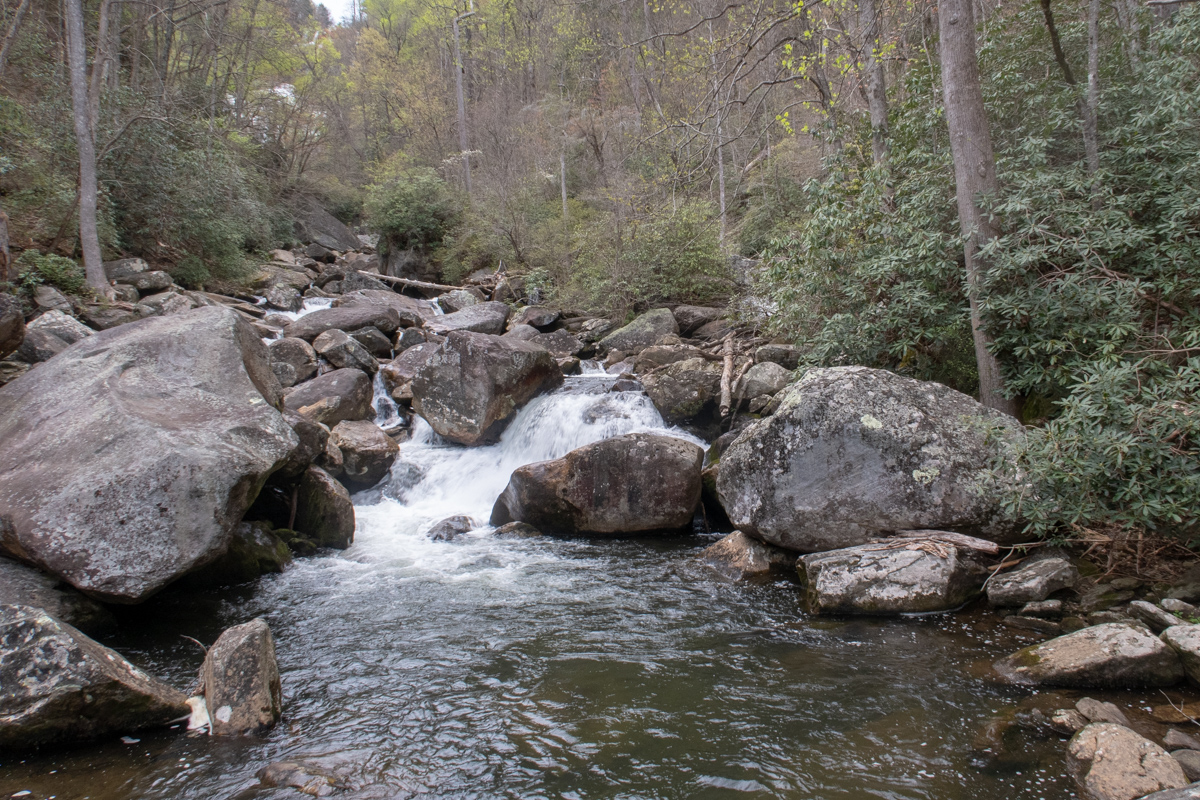
Hilliard Falls on a side trail 0.2 miles away. Normally I would ignore, but today I decided to check out the falls.

I left my backpack at the sign from the previous photo and walked to Hilliard Falls. It was worth it. This is 8.4 trail miles from the car.


Benches at the Bear Camp Creek campsite. Pumped drinking water both times I passed by this location.

Same campsite as the previous photo. Mabel always looks so comfortable when she sleeps. I wish I could fall asleep as quickly as her when I backpack.

Very sharp descent to Horsepasture River. The other side contains a similar incline.

Horsepasture River. Well constructed bridge.

A couple of miles after crossing Horsepasture River it was becoming darker, so I decided to settle in for the evening. Before I set up camp I had a brief conversation with Dave, KN4ZKT, on the Amateur Radio 2m N4AW repeater. This was a welcome contact with civilization since I only found cell service once during the trip - on the following day. Amateur Radio for the win.
Since there were no campsites near by, I rolled out my sleeping pad and sleeping bag on the ground. There was no rain in the forecast, so I didn't bother to set up my tent. It was a pleasant night, and I was able to start hiking on Friday morning by 8:00AM.
This was the point where I started heading back toward the car.

A suspension bridge - another marvel of engineering in the middle of nowhere.

Coley Creek Campsite, where I chatted again with Dave on Amateur Radio. There was no cell phone reception here.
I continued walking back to Thompson River, where I rinsed the clothes I was wearing, ate lunch, jumped in the cold water, and sunbathed. I spent almost two hours, and it was great. In that time my clothes dried acceptably.

Back at the trail intersection.

Photo from another angle showing Mabel sleeping again.
Since I planned to camp near this area on my second night and I had some time to kill before the sun set, I decided to walk the 0.5 mile side trail to the parking lot where I was originally supposed to leave my car. I didn't bring my pack or camera. The huge parking lot was empty except for a couple of parked tractor trailers. I remembered the Duke Energy gatekeeper telling me the previous day that the power plant was exceptionally busy.

Set camp again in the middle of the trail. No tent, just a ground pad and sleeping bag. At 7:40AM on Saturday morning there were some slight sprinkles, so I quickly broke down camp and hit the trail on the 3.1-mile, 1000+ foot climb back to the car. Fortunately the sprinkles only lasted a few minutes.

Lake Jocassee is visible in the distance near the final ascent back to the car. This is the lake that all of the streams I crossed lead to.
Arrived at the car at 9:45AM Saturday and headed home.